Maine Tide Chart & Weather on Windows Pc
Developed By: NestTides
License: Free
Rating: 5,0/5 - 1 votes
Last Updated: February 26, 2025
App Details
| Version |
1.0 |
| Size |
11 MB |
| Release Date |
January 24, 18 |
| Category |
Weather Apps |
|
What's New:
Updated Tide Stations for Maine [see more]
|
|
Description from Developer:
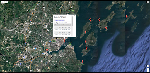
Accurate, simple to use Satellite Map based Maine tide charts of all NOAA based Maine tide stations. Designed by Maine fishermen and Professional Maine Fishing Guides.
NO SPAM ADS... [read more]
|
About this app
On this page you can download Maine Tide Chart & Weather and install on Windows PC. Maine Tide Chart & Weather is free Weather app, developed by NestTides. Latest version of Maine Tide Chart & Weather is 1.0, was released on 2018-01-24 (updated on 2025-02-26). Estimated number of the downloads is more than 10. Overall rating of Maine Tide Chart & Weather is 5,0. Generally most of the top apps on Android Store have rating of 4+. This app had been rated by 1 users, 1 users had rated it 5*, 1 users had rated it 1*.
How to install Maine Tide Chart & Weather on Windows?
Instruction on how to install Maine Tide Chart & Weather on Windows 10 Windows 11 PC & Laptop
In this post, I am going to show you how to install Maine Tide Chart & Weather on Windows PC by using Android App Player such as BlueStacks, LDPlayer, Nox, KOPlayer, ...
Before you start, you will need to download the APK/XAPK installer file, you can find download button on top of this page. Save it to easy-to-find location.
[Note] You can also download older versions of this app on bottom of this page.
Below you will find a detailed step-by-step guide, but I want to give you a fast overview of how it works. All you need is an emulator that will emulate an Android device on your Windows PC and then you can install applications and use it - you see you're playing it on Android, but this runs not on a smartphone or tablet, it runs on a PC.
If this doesn't work on your PC, or you cannot install, comment here and we will help you!
Step By Step Guide To Install Maine Tide Chart & Weather using BlueStacks
- Download and Install BlueStacks at: https://www.bluestacks.com. The installation procedure is quite simple. After successful installation, open the Bluestacks emulator. It may take some time to load the Bluestacks app initially. Once it is opened, you should be able to see the Home screen of Bluestacks.
- Open the APK/XAPK file: Double-click the APK/XAPK file to launch BlueStacks and install the application. If your APK/XAPK file doesn't automatically open BlueStacks, right-click on it and select Open with... Browse to the BlueStacks. You can also drag-and-drop the APK/XAPK file onto the BlueStacks home screen
- Once installed, click "Maine Tide Chart & Weather" icon on the home screen to start using, it'll work like a charm :D
[Note 1] For better performance and compatibility, choose BlueStacks 5 Nougat 64-bit read more
[Note 2] about Bluetooth: At the moment, support for Bluetooth is not available on BlueStacks. Hence, apps that require control of Bluetooth may not work on BlueStacks.
How to install Maine Tide Chart & Weather on Windows PC using NoxPlayer
- Download & Install NoxPlayer at: https://www.bignox.com. The installation is easy to carry out.
- Drag the APK/XAPK file to the NoxPlayer interface and drop it to install
- The installation process will take place quickly. After successful installation, you can find "Maine Tide Chart & Weather" on the home screen of NoxPlayer, just click to open it.
Discussion
(*) is required
Accurate, simple to use Satellite Map based Maine tide charts of all NOAA based Maine tide stations. Designed by Maine fishermen and Professional Maine Fishing Guides.
NO SPAM ADS, SIMPLE TO USE...100% AD FREE.
Other Features:
Ability to forecast Maine tides from NOAA by setting date and period for any of the tidal stations for the entire State of Maine tide tables.
Excellent support for any issues, questions or new features...simply email: info@nestides.com and we'll show you how Apple support is meant to be.
Auto saves your GPS location so you can return quickly next time you use the tide app.
Included is the ability to zoom and view satellite imagery for fishing ground characteristics to compare with tide movement.
Advanced tide graphs allow for you to judge the level of water movement for optimal fishing between high and low tide between tide stations so you can follow the tide flow for the entire day.
Recent Feedback:
"NesTides ability to display tide predictions and actual tidal flow graphs allow me to extend fishing trips by following different tide station tide charts and moving with the tide flow. The satellite view allows me to explore and discover new fishing grounds I never knew existed. Absolutely the best fishing software tool I have ever used. ," said USCG Captain Mike K.
Partial list of NOAA Maine Tide Stations, see website for full list:
Pettegrove Point, Dochet Island,EASTPORT,Garnet Point, Pennamquan River,Coffins Point,Birch Islands,Gravelly Point, Whiting Bay,Cutler, Little River,Cutler, Naval Radio Station,Stone Island, Machias Bay,Machiasport, Machias River,Shoppee Point, Englishman Bay,Steele Harbor Island,Millbridge, Narraguagus River, Maine,Green Island, Petit Manan Bar,Prospect Harbor,BAR HARBOR,Southwest Harbor,Bass Harbor,Winter Harbor, Frenchman Bay,Blue Hill Harbor,Mackerel Cove,Ellsworth, Union River,Burnt Coat Harbor, Swans Island,Center Harbor,Little Deer Isle,Isle Au Haut,Oceanville, Deer Isle,Stonington, Deer Isle,Matinicus Harbor, Wheaton Island,Vinalhaven, Vinalhaven Island,North Haven,Castine,Pulpit Harbor, North Haven Island,Fort Point, Penobscot River,Gross Point, Eastern Channel,Bucksport,Winterport,Sandy Point,Bangor,Belfast,Rockland,Tenants Harbor,Monhegan Island,Burnt Island, Georges Islands,Port Clyde,Otis Cove,Thomaston,New Harbor, Muscongus Bay,Muscongus Harbor, Muscongus Sound,Friendship Harbor,Pemaquid Harbor, Johns Bay,Jones Neck,Waldoboro,East Boothbay,Walpole,Newcastle,Damariscove Harbor, Damariscove Island,Boothbay Harbor,Southport, Townsend Gut,Isle of Springs,Cross River entrance,Wiscasset,Sheepscot (below rapids),Back River,Robinhood, Sasanoa River,Mill Point, Sasanoa River,Fort Popham, Hunniwell Point,Phippsburg,Bath,Sturgeon Island, Merrymeeting Bay,Androscoggin River entrance,Brunswick, Androscoggin River,Bowdoinham, Cathance River,Cundy Harbor, New Meadows River,Howard Point, New Meadows River,South Harpswell, Potts Harbor,Wilson Cove, Middle Bay,South Freeport,Prince Point,Doyle Point,Falmouth Foreside,Great Chebeague Island,Cliff Island, Luckse Sound,Vaill Island,Long Island,Cow Island,Presumpscot River Bridge,Back Cove,Great Diamond Island,Peak Island,Cushing Island,PORTLAND,Fore River,Portland Head Light,Pine Point, Scarborough River,Old Orchard Beach,Camp Ellis, Saco River Entrance,Biddeford, Saco River,Cape Porpoise,Kennebunkport,Wells, Webhannet River,Cape Neddick,York Harbor,Fort Point, York Harbor,Seapoint, Cutts Island
high tide, low tide, maine tide chart, maine tides, southern maine tide chart, tide chart, tide schedule, tide schedule maine, tides, when is high tide
Updated Tide Stations for Maine