GPS Waypoints on Windows Pc
Developed By: Bluecover Technologies
License: Free
Rating: 3,8/5 - 1.624 votes
Last Updated: April 03, 2025
App Details
| Version |
3.13 |
| Size |
14.3 MB |
| Release Date |
December 15, 24 |
| Category |
Tools Apps |
|
App Permissions:
Allows an app to access precise location. [see more (9)]
|
|
What's New:
Version 3.13- Fixes on share Points to file and bluetooth- Show Regional Datum conversion on Waypoints and Settings (Premium)- Export Points to Geodata Viewer... [see more]
|
|
Description from Developer:
Multi-purpose mapping and surveying tool for both professional and personal use. The tool is valuable in several professional land-based surveying activities, including agriculture... [read more]
|
About this app
On this page you can download GPS Waypoints and install on Windows PC. GPS Waypoints is free Tools app, developed by Bluecover Technologies. Latest version of GPS Waypoints is 3.13, was released on 2024-12-15 (updated on 2025-04-03). Estimated number of the downloads is more than 500,000. Overall rating of GPS Waypoints is 3,8. Generally most of the top apps on Android Store have rating of 4+. This app had been rated by 1,624 users, 338 users had rated it 5*, 947 users had rated it 1*.
How to install GPS Waypoints on Windows?
Instruction on how to install GPS Waypoints on Windows 10 Windows 11 PC & Laptop
In this post, I am going to show you how to install GPS Waypoints on Windows PC by using Android App Player such as BlueStacks, LDPlayer, Nox, KOPlayer, ...
Before you start, you will need to download the APK/XAPK installer file, you can find download button on top of this page. Save it to easy-to-find location.
[Note] You can also download older versions of this app on bottom of this page.
Below you will find a detailed step-by-step guide, but I want to give you a fast overview of how it works. All you need is an emulator that will emulate an Android device on your Windows PC and then you can install applications and use it - you see you're playing it on Android, but this runs not on a smartphone or tablet, it runs on a PC.
If this doesn't work on your PC, or you cannot install, comment here and we will help you!
Step By Step Guide To Install GPS Waypoints using BlueStacks
- Download and Install BlueStacks at: https://www.bluestacks.com. The installation procedure is quite simple. After successful installation, open the Bluestacks emulator. It may take some time to load the Bluestacks app initially. Once it is opened, you should be able to see the Home screen of Bluestacks.
- Open the APK/XAPK file: Double-click the APK/XAPK file to launch BlueStacks and install the application. If your APK/XAPK file doesn't automatically open BlueStacks, right-click on it and select Open with... Browse to the BlueStacks. You can also drag-and-drop the APK/XAPK file onto the BlueStacks home screen
- Once installed, click "GPS Waypoints" icon on the home screen to start using, it'll work like a charm :D
[Note 1] For better performance and compatibility, choose BlueStacks 5 Nougat 64-bit read more
[Note 2] about Bluetooth: At the moment, support for Bluetooth is not available on BlueStacks. Hence, apps that require control of Bluetooth may not work on BlueStacks.
How to install GPS Waypoints on Windows PC using NoxPlayer
- Download & Install NoxPlayer at: https://www.bignox.com. The installation is easy to carry out.
- Drag the APK/XAPK file to the NoxPlayer interface and drop it to install
- The installation process will take place quickly. After successful installation, you can find "GPS Waypoints" on the home screen of NoxPlayer, just click to open it.
Discussion
(*) is required
Multi-purpose mapping and surveying tool for both professional and personal use. The tool is valuable in several professional land-based surveying activities, including agriculture, forest management, infrastructure maintenance (e.g. roads and electrical networks), urban planning & real estate and emergencies mapping. It is also used for personal outdoor activities, such as hiking, running, walking, travelling and geocaching.
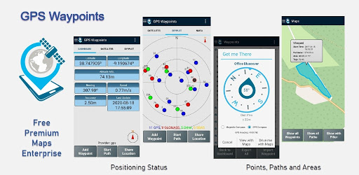
The application collects Points (such as points of interest) and Paths (sequence of points) to perform mapping and surveying activities. The Points, that are acquired with accuracy information, can be classified by the user with specific tags or characterized with photos. The Paths are created as a temporal sequence of newly acquired Points (e.g. to record a track) or alternatively with existing Points (e.g to create a route). Paths allows to measure distances and, if closed, forms Polygons that allows the determination of areas and perimeters. Both Points and Paths can be exported to a KML, GPX and CSV file and thus be processed externally with a geospatial tool.
The application uses the internal GPS receiver from the mobile device (typically with accuracies >3m) or, alternatively, allows professional users attaining better accuracies with a Bluetooth external GNSS receiver compatible with NMEA stream format (e.g. RTK receivers with centimeter level precision). See below some examples of the external receivers supported.
The application includes the following features:
- Acquire current position with accuracy and navigation information;
- Provide details of the active and visible satellites (GPS, GLONASS, GALILEO, BEIDOU and other);
- Create Points with accuracy information, classify them with Tags, attach photos and convert coordinates into a human-readable address (reverse geocoding);
- Import Points from geographic coordinates (lat, long) or by searching for a street address/point of interest (geocoding);
- Create Paths by acquiring sequences of points manually or automatically;
- Import Paths from existing Points;
- Create survey's themes with custom Tags for classifing Points and Paths
- Get directions and distances from current position to Points and Paths using a magnetic or gps compass;
- Export Points and Paths to KML and GPX file format;
- Share data with other applications (e.g. Dropbox/Google Drive);
- Configure positioning source for the internal receiver or using an external receiver.
The Premium subscription include the following professional features:
- Backup and restore user's data (it also allows transfer data from one handset to another);
- Export Waypoints and Paths to CSV file format;
- Export Waypoints with photos to KMZ file
- Import multiple Points and Paths from CSV and GPX files;
- Sort and filter Points and Paths by creation time, name and proximity;
- Satellite signal analysis and interferences detection.
The Maps feature is an extra paid funcionality that allows selecting and visualizing your Points, Paths and Polygons on Open Street Maps.
Additionally to the internal mobile receiver, the current version is known to work with the following external receivers: Bad Elf GNSS Surveyor; Garmin Glo; Navilock BT-821G; Qstarz BT-Q818XT; Trimple R1; ublox F9P.
If you successfully tested the application with another external receiver please provide us your feedback as a user or manufacturer in order to extend this list.
For further information check our site (https://www.bluecover.pt/gps-waypoints) and get the details of our complete offer:
- Free and Premium features (https://www.bluecover.pt/gps-waypoints/features)
- GISUY Receivers (https://www.bluecover.pt/gisuy-gnss-receiver/)
- Enterprise (https://www.bluecover.pt/gps-waypoints/enterprise-version/)
Version 3.13
- Fixes on share Points to file and bluetooth
- Show Regional Datum conversion on Waypoints and Settings (Premium)
- Export Points to Geodata Viewer tool
- Enterprise improvements for cooperation between users
Version 3.12
- Regional Datum conversions improvements
- Add Points manually on Maps
- Manage Layers on Maps improvements
- Shortkeys, Path kml export, photos permissions and SDK updates
- Satellite image mapping request (Trial)
Allows an app to access precise location.
Allows an app to access approximate location.
Allows an application to write to external storage.
Allows applications to connect to paired bluetooth devices.
Allows applications to discover and pair bluetooth devices.
Allows applications to open network sockets.
Allows applications to access information about networks.
Allows using PowerManager WakeLocks to keep processor from sleeping or screen from dimming.
Allows an application to read from external storage.